


2020-09-25_08h30m31_Maline Rougon

gerardmicheline
User
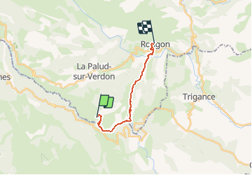

Length
12.9 km

Max alt
965 m

Uphill gradient
1157 m
Km-Effort
28 km

Min alt
556 m

Downhill gradient
1090 m
Boucle
No
Creation date :
2020-09-25 06:30:31.607
Updated on :
2020-09-25 17:41:12.866

FREE GPS app for hiking
 SityTrail
IGN / Geographical institutes
SityTrail Plus
The world is yours!
About
Trail of 12.9 km to be discovered at Provence-Alpes-Côte d'Azur, Alpes-de-Haute-Provence, La Palud-sur-Verdon. This trail is proposed by gerardmicheline.
Positioning
Country:
France
Region :
Provence-Alpes-Côte d'Azur
Department/Province :
Alpes-de-Haute-Provence
Municipality :
La Palud-sur-Verdon
Location:
Unknown
Start:(Dec)
Start:(UTM)
286234 ; 4847134 (32T) N.
Comments